Albatross

Heavy lift
and long endurance
flying platform


Built with aircraft-grade materials and designed for severe weather resilience, this drone is engineered to excel in the toughest conditions. With advanced features it’s the ultimate solution for professionals who demand reliability, versatility, and cutting-edge technology.

Engineered for elite performance, our next-generation UAV is purpose-built to thrive in demanding environments where failure is not an option. Whether you’re navigating harsh terrain, extreme weather, or high-stakes missions, this drone delivers unmatched reliability, precision, and operational flexibility. Backed by rugged construction and cutting-edge innovation, it empowers professionals across industries to gather critical data, conduct complex missions, and push boundaries—all with confidence.

Features

Our UAV is packed with state-of-the-art features designed to meet the rigorous demands of modern operations. From unmatched durability and weather resistance to advanced automation, precision GPS, and modular payload systems, every component is purpose-built to deliver reliability, flexibility, and mission success in any environment. Whether you’re navigating rugged terrain, capturing high-resolution data, or operating in extreme conditions, this UAV is ready to perform—no compromises.

 
icon_time

1 hour flight time

icon_kg

Up to 10 kg payload

icon_fold

Foldable to small size


Durable and lightweight construction

The UAV is built using a robust combination of aircraft-grade aluminum and carbon fiber, ensuring both strength and lightweight performance. This high-quality construction offers exceptional durability, making it capable of withstanding the toughest operational conditions while maintaining an efficient flight profile. The use of aircraft-grade aluminum provides a solid, rigid structure, while the carbon fiber components reduce weight, enhancing the UAV’s maneuverability and endurance. This material blend ensures the UAV remains reliable and resilient, whether it’s deployed in harsh weather, challenging environments, or demanding missions.

albatross_small05

Weather resilience

Our UAV is built to perform in severe weather conditions, with advanced systems that allow it to operate reliably even in harsh environments. Whether it’s strong winds, heavy rain, or extreme temperatures, the UAV is equipped with weather-resistant components designed to protect sensitive electronics and ensure consistent flight performance. With enhanced sealing and protective coatings, it minimizes the impact of adverse weather, enabling it to carry out missions in challenging conditions, from search and rescue operations to industrial inspections in tough climates. This resilience ensures dependable operation no matter what the forecast holds.

albatross_small06

Quick release payload

The UAV is equipped with a quick-release payload interconnect that allows for seamless integration and rapid swapping of various payloads, providing both power and data connectivity. This innovative feature simplifies mission setups and enables fast adaptation to different tasks without the need for complex configurations or downtime. Whether you’re switching from a camera system to a LiDAR sensor or changing payloads for specific surveys, the quick-release system ensures smooth transitions, enhancing operational efficiency and flexibility. This capability empowers users to tailor the UAV for a wide range of applications, ensuring maximum productivity in dynamic environments.

albatross_small09

Fully automated missions

Our UAV is equipped with fully automated mission capabilities, enabling it to execute complex flight plans with minimal human intervention. This advanced feature allows the drone to autonomously navigate through pre-set waypoints, ensuring precision and efficiency for a wide range of applications, from surveying to surveillance. Additionally, the UAV boasts a unique moving platform landing capability, allowing it to land on dynamic, moving surfaces such as vehicles or ships, even in challenging conditions. This feature enhances operational flexibility, making the UAV ideal for continuous, high-precision data collection in ever-changing environments.

albatross_small08

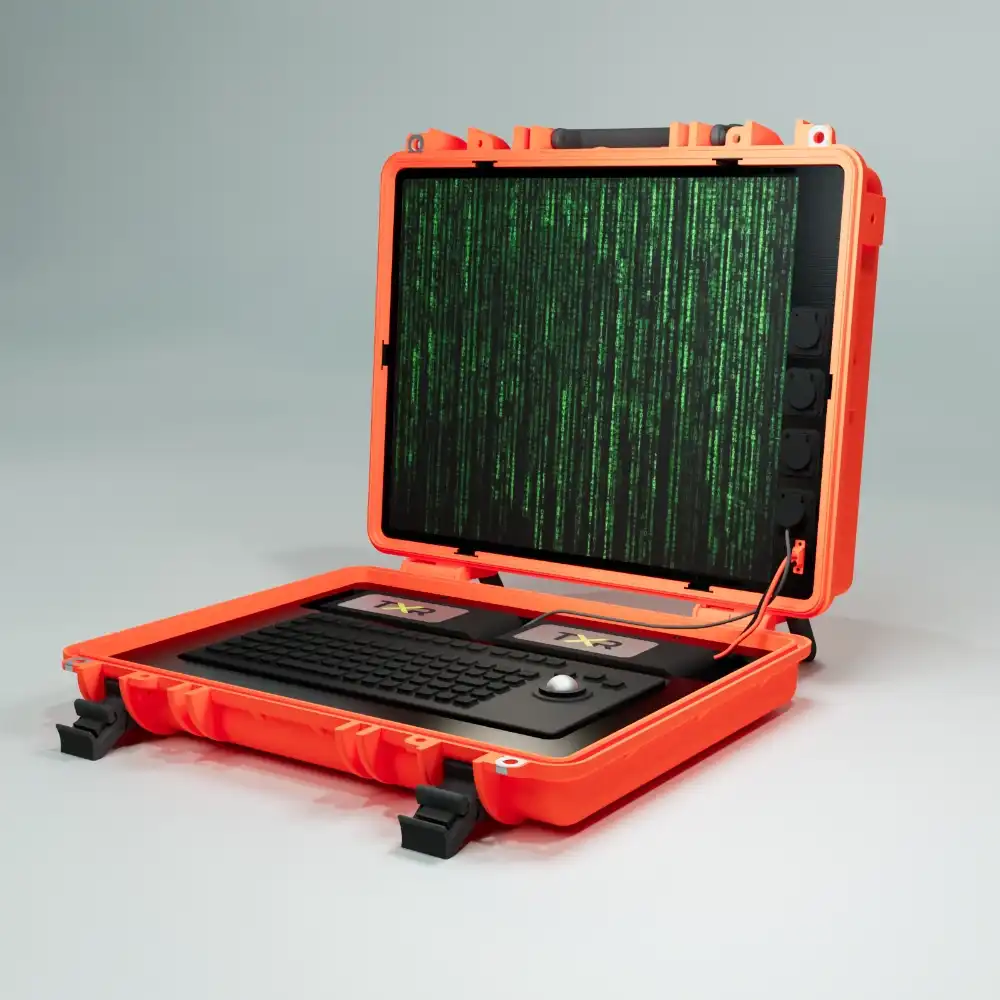
MILSPEC ground station

The UAV is paired with a rugged MILSPEC ground station, designed to withstand challenging environments and ensure reliable control and communication. With a direct datalink range of up to 50km, the ground station offers extended operational reach, allowing users to maintain constant connectivity and precise control over long distances. Whether in remote or harsh locations, this durable, high-performance ground station ensures uninterrupted data transmission and seamless command execution, making it ideal for extended missions and demanding field conditions.

GCS_small01

RTK GPS capability

The UAV is equipped with surveying-grade RTK GPS capability, offering centimeter-level accuracy for highly precise mapping and surveying tasks. This advanced system ensures reliable, real-time georeferencing, making it ideal for applications that require exceptional precision, such as topographic surveys, construction site monitoring, and infrastructure inspections. By reducing the need for ground control points, the RTK GPS system enhances operational efficiency and ensures the accuracy of collected data, even in challenging environments. Whether for large-scale land surveys or detailed structural assessments, this feature guarantees unparalleled precision and reliability.

albatross_small07

HD flight cameras

Our UAV offers the option to equip front and down-facing flight cameras, providing comprehensive visual coverage for a variety of applications. These high-definition cameras deliver real-time, long-range video downlink, ensuring you have clear, high-quality visuals no matter the distance or environment. Whether you’re conducting inspections, monitoring wildlife, or performing search and rescue missions, these cameras offer enhanced situational awareness, allowing operators to make informed decisions based on live footage. The flexibility to choose the camera setup ensures the UAV can be tailored to specific mission requirements, offering optimal performance in diverse scenarios.

albatross_small02

Open software and hardware

Our UAV is built with an open software and hardware platform, offering unparalleled flexibility for customization and integration with customer-specific applications. This open architecture allows users to easily modify and expand the system to suit unique operational needs, whether through third-party software or specialized hardware. Whether you’re developing custom payloads, enhancing mission capabilities, or integrating with existing infrastructure, the open platform ensures the UAV can evolve alongside your requirements, providing a fully adaptable solution for a wide range of industries and use cases.

albatross_small01
albatross_wide2

Variable payload

Our UAV platform is equipped with a wide range of advanced sensors designed for diverse applications, including high-resolution optical cameras, multispectral imaging, LiDAR scanning, and thermal or radiometric sensing. With additional capabilities in magnetic surveys and geophysical measurements, it offers a versatile and customizable solution for precise data collection across various industries.

Optical and Imaging Sensors

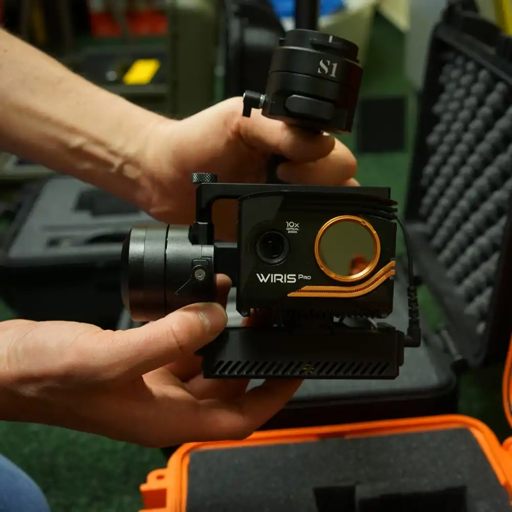
Our UAV offers exceptional flexibility with customizable optical and imaging sensors, allowing you to choose between high-resolution cameras like the 24MP and 61MP full-frame sensors for precise surveying and mapping. For specialized applications, you can integrate a multispectral narrowband camera, ideal for environmental monitoring or agriculture. The combined surveillance sensor, which includes thermal, optical, video, and laser ranging instruments, can also be added to provide comprehensive situational awareness for security or inspection missions. With the option to tailor your payload, the UAV adapts to a wide range of imaging needs.

  • Optical surveying 24Mpix APSC camera with Sony E-type objective mount

  • Optical surveying 61Mpix full-frame camera with Sony E-type objective mount

  • Multispectral narrow band camera with quad lens optics and 61Mpix Sony full-frame sensor

  • Combined surveillance high-resolution sensor with thermal, optical, video, and laser ranging instruments

optical

Thermal and Radiometric Sensors

The UAV platform is designed for easy customization with a variety of thermal and radiometric sensors. You can choose from advanced radiometric infrared (IR) cameras based on FLIR technology for accurate thermal imaging and temperature analysis. For more complex operations, the combined surveillance sensor adds thermal, optical, and video capabilities in one versatile package, allowing for enhanced surveillance and monitoring in low-light or adverse conditions. These sensors can be integrated based on your specific mission requirements, offering a tailored solution for thermal and radiometric data collection.

  • Radiometric IR camera with optical overlay based on FLIR sensor

  • Combined surveillance high-resolution sensor with thermal, optical, video, and laser ranging instruments

LiDAR and Scanning Sensors

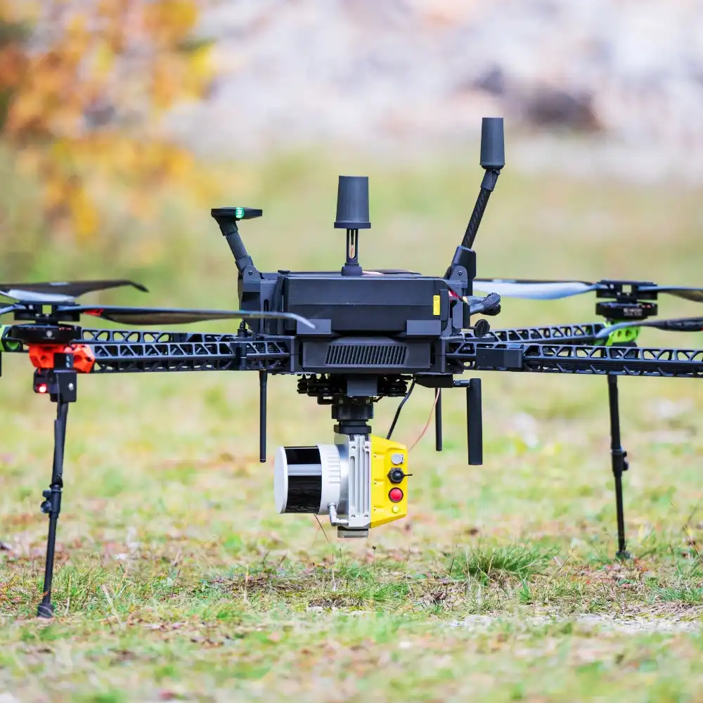
Our UAV supports customizable payloads, including the option to integrate a 128-channel Ouster LiDAR sensor for high-precision surface and structural scanning. This sensor provides accurate 3D data collection, ideal for topographic mapping, vegetation analysis, and infrastructure inspections. Depending on your needs, you can select the LiDAR system that best fits your project requirements, ensuring the UAV provides the necessary precision for demanding scanning applications. The flexibility to choose LiDAR and scanning sensors ensures adaptability across a range of surveying and mapping tasks.

  • Scanning 128 channel Ouster LiDAR sensor for precision surface and structural scanning

Magnetic and Geophysical Sensors

Designed for flexibility, our UAV allows you to equip it with various geophysical sensors, such as the proton magnetometer or high-resolution magnetometer for magnetic surveys and geological exploration. These sensors are ideal for detecting subsurface anomalies, mapping mineral deposits, or conducting archaeological investigations. Additionally, you can integrate a gamma spectrometer for environmental monitoring and radiometric data collection. The customizable payload ensures that you can configure the UAV to suit your specific needs, whether for geological surveys, research, or environmental monitoring.

  • Proton magnetometer/gradiometer with 1-second sample time and integrated GPS and IMU

  • MagArrow MFAM sensor-based high-resolution magnetometer with integrated GPS and IMU

  • Gamma spectrometer

albatross_wide3

Technical specifications

Basic specifications

Frame size1300 mm diagonal motor axis span
Propellers32" carbon composite foldable
Power system50 V 25 Ah, 12S Lithium Polymer Dual Smart Battery
Payload mountGremsy Quick Release / Universal base plate / Custom
Payload electrical interconnectSerial / MAVLink / HDMI / Ethernet / USB / Power / Custom
Payload capacity8 kg (max for medium weather resiliency)
Operating limitsWind 10 m/s gusting 16 m/s, -10  ̊C to +40  ̊C 
UAV weight with batteries12.5 kg (with universal baseplate)
MTOW24 kg (configuration dependent)
Flight enduranceup to 70 min with 2 kg payload
Flight controllerTriple IMU and power redundant (Arducopter, PX4 or Hionos FW)
Ground stationSeveral options with Full HD sunlight readable screen and up to 40 km range
Frame construction7075 Aluminium foldable arms with carbon base plates
Companion computerOptional with AI co-processor, ethernet and MAVLink to ground station

Transport size and weight

Length770 mm
Width580 mm
Depth265 mm
Weight*24 kg

*without batteries


RTK / PPK GPS Option

Static horizontal accuracy4 mm + 0.5 ppm
Static vertical accuracy8 mm + 1 ppm
Kinematic horizontal accuracy7 mm + 1 ppm
Kinematic vertical accuracy14 mm + 1 ppm
CorrectionNTRIP, VRS, RTCM3
Data loggingRINEX @10 Hz, 16 GB storage
Radio linkLoRa 8 km, 868/915 MHz, LTE
InterfaceWi-Fi, BT 4.0/2.1 EDR, USB, UART, Event
SIgnals traced

GPS L1C/A,L2C, Galileo E1B/C,E5b

GLONASS L1OF, L2OF, Beidou B1I

Update rate10 Hz
Number of channels184

Target industries

Our UAV solutions are designed to meet the needs of a wide range of industries, including surveying and environmental monitoring, where precision data collection and real-time insights are critical. The platform is also ideal for security and law enforcement, providing reliable performance for surveillance, defense, and tactical operations. In emergency response and safety, our UAV ensures rapid deployment and efficiency, whether for search and rescue or firefighting. Additionally, it excels in inspection and delivery, offering versatile payload options for a variety of tasks requiring high accuracy and operational flexibility.

industry_geodesy

Geodesy and land surveying

Our UAV provides advanced solutions for geodesy and land surveying, offering precise fotogrammetry and 3D surface modelingcapabilities for accurate mapping. With high-resolution orthophotos and LiDAR scanning, it captures detailed surface and structural data, ensuring reliable results for a wide range of surveying applications.

industry_geophysics

Geophysics

In geophysics, our UAV platform enables advanced aerial magnetometry for detecting subsurface anomalies and mapping mineral deposits. It also supports gamma spectrometry for radiometric analysis and IR radiometry (thermal imaging) for detailed thermal assessments, making it an ideal solution for geological surveys and environmental monitoring.

industry_archeology

Archeology

In archaeology, our UAV excels in applications such as aerial magnetometry for detecting buried artifacts and structures, and IR radiometry (thermal imaging) for identifying heat signatures of ancient sites. Additionally, it offers LiDAR surface and structure scanning for detailed 3D mapping and multispectral imaging to analyze the environment and uncover hidden features of archaeological sites.

industry_agri

Agriculture

Our UAV is equipped for advanced IR radiometry (thermal imaging), allowing for efficient monitoring of crop health, irrigation, and soil moisture levels. Additionally, multispectral imaging provides detailed insights into plant vitality, growth patterns, and stress factors, helping optimize yields and enhance farm management practices.

industry_surveillance

Surveillance

Our UAV is perfect for surveillance applications, offering advanced object and area monitoring in both optical and thermal spectrums. With the capability to perform automated surveillance missions, it provides continuous, reliable monitoring for security, tactical, and situational awareness in various environments.

industry_law

Law enforcement 

Our UAV is highly effective in suspect searches, offering rapid deployment and real-time surveillance for law enforcement and security operations. It is also ideal for UXO (unexploded ordnance) searches, providing precise, safe detection in hazardous environments. Additionally, the UAV excels in searching for human bodies and other objects, delivering accurate data and enhancing efficiency in rescue and recovery operations

industry_defense

Defense

Our UAV excels in various applications, including object and area monitoring in both optical and thermal spectrums, offering enhanced surveillance and detection capabilities. It also supports automated surveillance missions, acts as flying radio and datalink repeaters, and facilitates radio spectrum monitoring or jamming. Additionally, the UAV is ideal for targeted delivery systems and plays a crucial role in land mine and UXO search and clearing, ensuring safety and efficiency in high-risk environments.

industry_emergency

Emergency and rescue

Our UAV features automated optical and thermal searching capabilities for efficient object and area identification in all conditions. It can also act as a flying radio or datalink repeater, extending communication range, while its flying lighting systems enhance visibility during nighttime operations. Additionally, the UAV ensures precise delivery of supplies and medications to remote locations, supporting healthcare, humanitarian, and logistics efforts.

industry_fire

Firefighting

Our UAV is equipped for forest fire detection and monitoring, providing real-time thermal imagery to detect early signs of fires in hard-to-reach areas. With an integrated early warning system, it can alert teams to potential threats, while fire spread monitoring offers continuous tracking of fire progression to help optimize response efforts. Additionally, the UAV can spot temperature differences, identifying hazardous agents or potential hot spots, ensuring proactive safety measures.

industry_inspection

Inspection

Our UAV enables automated monitoring and inspection of inaccessible structures, providing detailed, real-time data for hard-to-reach areas without the need for manual intervention. It is also highly effective for photoelectric power farm inspection, offering precise aerial imagery to assess the condition and performance of solar panels, ensuring optimal efficiency and early detection of potential issues.